

We’ve been struck by the strong response to our blog from last week which told you about a wildlife site, Dendles Wood, on the edge of Dartmoor – click here. We’re waiting for Natural England to respond to our list of questions about Dendles Wood. While we wait, we thought that we’d do something a bit different and tell you how you can find your nearest important wildlife site, your local Dendles Wood, on an interactive online map. Dendles Wood is a Site of Special Scientific Interest, which sounds terribly dull, but SSSIs (and ASSIs, Areas of Special Scientific Interest, in Northern Ireland) are a very important part of protecting nature across the UK. Here is some background information on SSSIs and ASSIs from Wikipedia – click here.
We’re going to concentrate on SSSIs now as there are thousands of them across Great Britain and they are all mapped on the same online system called MAGIC. If you visit the MAGIC site – https://magic.defra.gov.uk/MagicMap.aspx – you’ll find a familiar map of GB with a complicated-looking table of contents on its left hand side. Let’s imagine you live in Edinburgh and zoom in a bit on Scotland’s capital. You’ll see something like this:
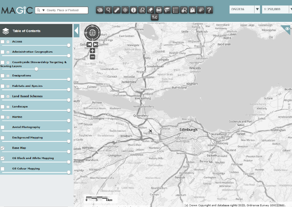
That looks familiar, doesn’t it? There is Edinburgh with its ring road and airport, the three bridges across the Firth of Forth and places like Loch Leven, east of Kinross, near the top of the map.
But where are the SSSIs? They are just a few clicks away – in fact, five clicks away. Look at the Table of Contents on the left hand side. SSSIs are ‘Designations’ so click the small box with a ‘+’ in it. Then choose (by clicking another small box with a ‘+’) ‘Land-based designations’, and then ‘Statutory’ and then, because we are looking at Scotland, ‘Sites of Special Scientific Interest (Scotland)’ and then, last click, the box which will shade in the actual boundaries of the SSSIs around Edinburgh in green and you will see something like this:
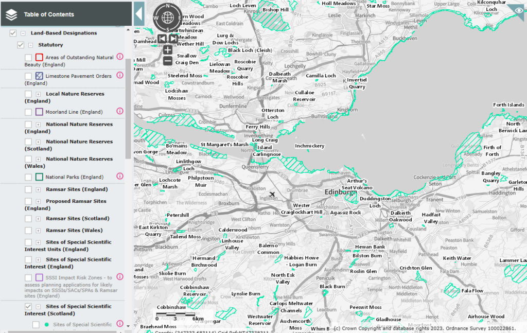
Same map, but with the SSSIs shaded in green. And now you can see that Arthur’s Seat in the middle of Edinburgh is a geological SSSI and that the Firth of Forth shores are SSSI, and Loch Leven up at the top of the map is an SSSI and there are lots more with titles such ‘burn’, ‘loch’, ‘marsh’, ‘muir’, ‘wood’, ‘moss’ and ‘glen’ that hint at why these sites may have been notified in the first place.
Just remember, if you are in Wales or England you need to click on the relevant ‘Sites of Special Scientific Interest ([nation])’ option.
But with five clicks you can see all of the SSSIs in Great Britain – you can zoom in and out of the map and you can visit all parts of England, Scotland and Wales. Happy travels! You’ll discover that some SSSIs cover thousands of hectares and others small fractions of a hectare, that some are well-known names and others you’ve never heard of, but all have been selected for their wildlife (and/or geological) value. They are sometimes referred to as the conservation jewels in the crown and to a large extent if the right sites are chosen, and if they are protected and well-managed, then they form a vital wildlife conservation network.
What is the nearest SSSI to your home? Did you know about it already? Have you ever been there? The notification of an SSSI does not confer rights of entry to the public but there may be a footpath through the SSSI, it may be owned by a conservation body which permits public access or it may be designated as open access – normal rules apply.
Now you have discovered that you live in a country with SSSIs dotted about all over it you may be curious to know more about your local SSSI. The following information is for England only because the systems differ in different UK nations and the English system is quite good and (to be honest) we understand it better than we do the Welsh or Scottish or Northern Irish systems.
Let’s go to East Anglia;
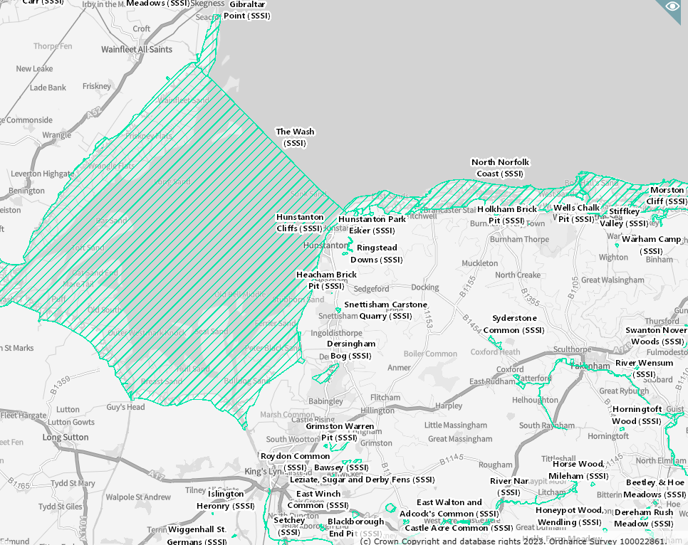
There’s The Wash, which is a massive SSSI, and the North Norfolk coast and scattered around are a lot of smaller, but still very important, SSSIs such as Dersingham Bog and Roydon Common.
Each SSSI is made up of units and you can see the units, and, importantly, their condition with another couple of clicks;
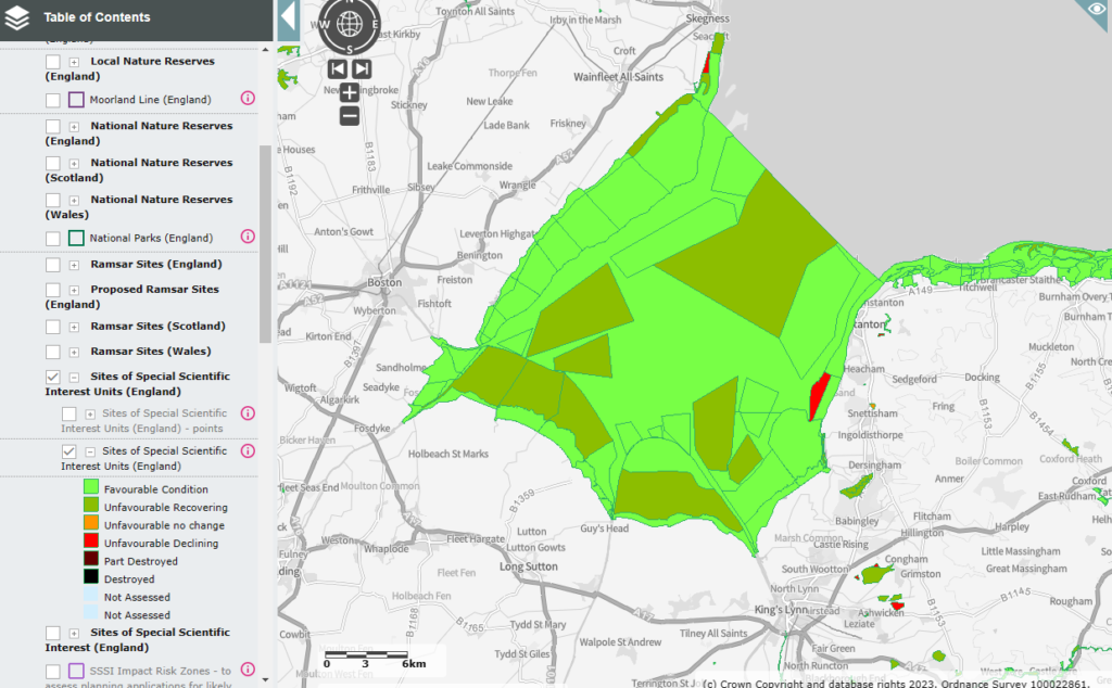
See? Now all the SSSIs, but let’s look at The Wash, are shown with their units mapped and each unit is classified, by Natural England, as being in Favourable Condition or not. Obviously, it would be good if all the SSSI units were shaded in light green as Favourable Condition but the more you look closely the more you will find that there are SSSI units in Unfavourable Condition. Don’t be fooled by the areas classed as Unfavourable Recovering – it sounds good but often isn’t. Sometimes it just means there is a plan for recovery and there is a wide gulf between having a plan on paper and having the right action on the ground.
And you can dig deeper into this information if you go to another website – this one https://designatedsites.naturalengland.org.uk/SiteSearch.aspx – where you will find a screen like this;
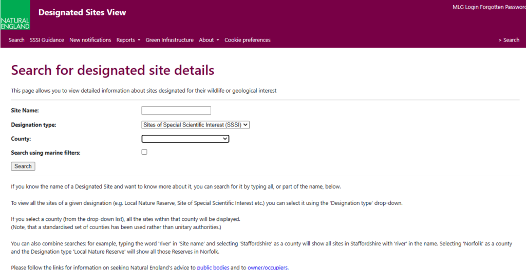
If you pop the name of the SSSI into the form (make sure it is the right name, let’s choose ‘The Wash’) and press ‘search’ you’ll get a screen like this one;
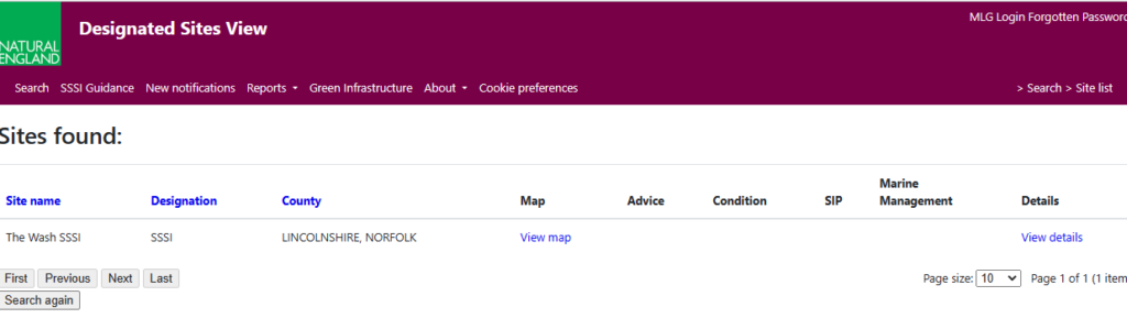
… then click on ‘View details’ and you’ll get this;
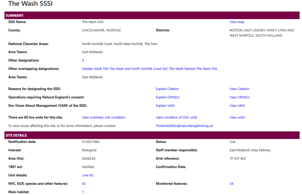
From this screen you can find out why The Wash was notified as an SSSI, what actions on site require Natural England’s permission, what Natural England thinks about how the site should be managed and information on the details behind the condition of all the SSSI units – in this case 60 of them that go to a couple of pages. If you do look at the unit condition assessments then you will find, just as was true for Dendles Wood, that the years on which some units were last assessed (according to this Natural England website) were a very long time ago. This isn’t news – lack of monitoring of SSSI condition is a well-known problem to professional nature conservationists. But if you live in England this system will allow you to check when your local SSSI was last assessed Was it ages ago? Have a look and see.
We may get back to you on this subject.